The plan was to walk out to The Back Wall in the Mt Buffalo National Park. However the wet spring had made the track difficult to follow in places and the local Park Ranger advised against it. So the amended trip took us out to South Buffalo View Point.
This lookout like the Back Wall provides both views North to some of the classical Mt Buffalo location such as the popular climbing site The Cathedral. Whilst in the opposite direction the distinctive Mt Cobbler is visible, further round to the West the plains around Wangaratta can be seen and on a clear day the Warby Ranges are visible and the now de-commissioned Lake Mokoan.
The walk is quite easy with no long steep climbs and only a very small amount of rock hoping to get to the lunch spot. The distance is not very long at around 8km and could easily be extend by first walking out to Dickenson Falls before returning to the cars at the former Tatra Inn site and morning tea. This easy trip would add another 3km to the walk and provide views to the East.
Tuesday, December 21, 2010
Sunday, November 7, 2010
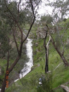
Salisbury Falls, Wenhams Loop
I would not have thought I would be back at Salisbury Falls quite so quickly, but when the opportunity to walk with people from other walking clubs came along I could not pass it up.
Regardless of following in our foot steps from a few weeks earlier the bush still provided a different look and feel.
Whilst it had rain earlier in the week the track was a lot drier and there was less water coming over the Falls. This time instead of take the short route from Mt Warby to the Alpine View Track, we continued onto Lunch at Wenhams, (a drive in camping area). After lunch we continue north along the Friends track, stopping at Kwat Kwat lookout for the stunning views before reaching the Alpine View track. Towards the end of the Alpine View track we “attacked” by A Grey Fantail which we believe was protecting us from its nest, as I said at the start it’s always different.

Saturday, October 30, 2010
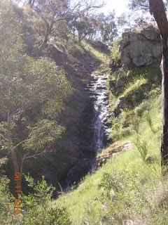
Salisbury Falls and Mt Warby
Like the Moonlight track walk the recent rain heavy rains made this a completely different walk to the other times I have walked through here.
Salisbury falls which I have only ever seen with a trickle going over were running very well. After lots of photos we headed off up the track to the top of the falls it was here we stopped for our morning tea and to take in the views.
Following the track to Mt Warby provided us with more wide flowers, Grass trees and water to look at. The views from Mt Warby are limited but before reaching the summit the bush does open up to good views to the south, which provides a look at Mt Glenrowan from an angle which it is not normally seen.
After Mt Warby it was off down the Alpine views track this track provides some great views across the Ovens Valley towards the Alps’ the only problem is you also need to look were you putting your feet :) The Alpine views track eventually joins up with the Mt Warby track, it is then a simple natter of back tracking past the falls to the waiting cars.

Thursday, October 28, 2010
Chick Hill and Moonlight track
The weather for this walk was quite cool with snow forecast down to 500m! However we were very lucky with only one short shower of rain requiring the putting on of rain jackets. The highlight of this trip had to be the water falls along Moonlight track, they provided plenty of photo’s for the group and a very pleasant spot to eat our lunch.


Monday, October 25, 2010
Long Range Track Mt Sugarloaf Eldorado
This area is only a few Kilometres from the Kangaroo Hill walk. Long Range track climbs up from Woolshed road to the Old Coach road, the views from this track differed to the Kangaroo Hill walk as they looked more towards Beechworth. The opposite ridge is the site of Police and Kelly caves, which would have provided both groups with a good view of the comings and goings in the Woolshed valley. Once reaching the Old Coach road we headed north to the start of Warners Track this led us to Mt Sugarloaf where we stopped for a well earned lunch. The return to the cars was a simple matter of following Warners Track. This track was a little steep in places but quickly lead us back down into the valley.
Sunday, October 24, 2010
Kangaroo Hill Eldorado
Kangaroo Hill provides good views across the Plains of Wangaratta and around towards Milawa.
We accessed the hill by walking up the ridge line that starts near the ford on Woolshed Road. After enjoying morning tea we followed the ridge generally north. At a suitable point we then headed down a spur line to Clear Creek, we continued up stream a short distance to a set of falls for lunch. With the recent rains these fall had plenty of water.
After a pleasant break we headed off downstream, often swapping from one side of the creek to the other to get the best going. Clear creek runs into the Reedy creek, and near the junction we found a spot that was shallow enough for s to cross in bear feet, the near knee deep water was quite cool. After drying off and putting boots back on we set off again. After a short distance a well used track was found on the Eastern side of Reedy creek, this made waking quite easy and gave me time to reflect on the miners who would have also followed this track to and from the diggings to Eldorado. The trip was finished of with Ice creams at the Eldorado store.

Saturday, August 14, 2010
Mt Lady Franklin
Mt Lady Franklin
There is some debate amongst the locals regarding which hill is really Mt Lady Franklin. The one we walked to has the telecommunication towers on it, however a lower hill which is quite close to Barnawartha is often put forward as the “real” Mt Lady Franklin, despite what the maps say.

Looking twoards Barnawartha.
The hill is named after Lady Jane Franklin who is said to have stop nearby on a trip from Melbourne to Sydney, information about this pioneering Lady can be found at,
http://en.wikipedia.org/wiki/Jane_Griffin_(Lady_Franklin)
Regardless of the name the hill offers great views in all direction. Snow covered peaks in NSW and Vic were visible along with a large number of other popular walking spots.
It was a pleasant day for walking with the sun out for most of the day and a breeze from the North to stop us getting too hot.
The walk is mostly through open farm land although there was a section of natural bush walked through on the way back to the cars.

This rock was spotted on the way back and reminded me of a Monkey.
Tuesday, May 25, 2010
Bright to Wandiligong
The walk took us along the Morse’s creek from Bright to Wandiligong (Wandi)
This track starts in by taking you through a caravan park, goes behind the houses and a sports ground before the mix of Pine plantation and natural bush that makes up most of the trip. It is a well worn track used since the days of the Gold mining and plenty of evidence from the mining days can still been seen in the earth works. Before reaching the Alpine Park with its play area containing a large fort the track once again travels along the edge of private property.
Once at the Park we went onto the Wandi Maze, this is well worth the visit if no other reason than to try the Miners Sponge cake. Once finding our way out of the Maze we returned to the Alpine Park for a picnic lunch before walking the 6Km back to Bright.
Saturday, April 24, 2010
Mt Glenrowan
Mt Glenrowan is an easy walk from the locked gate on the Taminick Gap road. This time instead of walking along the bitumen road that leads to the communication towers, we turn right onto a foot pad about 300m in from the gate.
This track leads across to the Casuarina track. Turning left then takes you back to the Ridge track near the large water tank. The Casuarina track offers good views to the west. Once at the water tank we continued along an old jeep track until it re-joined the Ridge track.
From here it is a simple matter of following the Ridge Track to the summit of Mt Glenrowan. Unfortunate for us it was a day of low cloud and some drizzle so the view across to the Victorian Alp’s was lost in the cloud, so we did not linger here for very long.
For a change we walked the 400m down the Bluff track to its end with some views across the plains to Lake Mokoan it was a pleasant spot for lunch. The return trip took us to Chick Hill and this time remaining on the Ridge track we returned to the lock gates and awaiting cars. No photo’s this time.
Sunday, April 11, 2010
Ballroom Track

The Ballroom track runs between the Mt Buffalo Rd and the Reservoir track on Mt Buffalo.
The track is only 1km long but finishes quite some distance from the start so a lift is required. I found myself in the position of having a convenient lift so I took the opportunity to walk this track.
The first 300m or so of the track is within re-growth from the 2003? Alpine Fires. After the re-growth the track opens out in to older bush. The track (I assume) was originally a jeep track as the cut marks can still be seen in the older sections of the bush.
I was lucky enough to disturb two Lyre Birds, they took off into the bush making quite a racket.
The track finished with a rock hop across Crystal Brook. The junction of the two tracks is not well marked on Reservoir road.

Sunday, March 21, 2010
Sil Shelter
I have had the Integral Designs Sil-Shelter for a little while now. I had practise putting it up a few times before a planned walk this weekend. However the plan fell through, so the opportunity to take some action photos was lost. So to make up for it I set it up the yard and got the camera out.
As others have mention the shelter is tight for two, but for me since I wanted the flexibility of a shelter big enough for two but not too heavy to carry it when I was one, I was happy with ID Sil-Shelter.
The photos show it with a SMD Meteor Bivvy; I will in the future get the matching ID Sil-Shelter Bug Liner to go with the shelter.
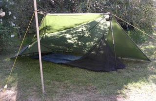
As others have mention the shelter is tight for two, but for me since I wanted the flexibility of a shelter big enough for two but not too heavy to carry it when I was one, I was happy with ID Sil-Shelter.
The photos show it with a SMD Meteor Bivvy; I will in the future get the matching ID Sil-Shelter
 Bug Liner to go with the shelter.
Subscribe to:
Posts (Atom)