Saturday, September 22, 2012
Leanganook Track, days 3 and 4
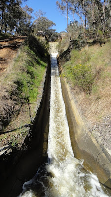
Day 3 saw me complete the descent down to the Coliban channel. I had arranged for a second water drop here which I collected before continuing along the channel. The channel offers some interesting old stone work and one has to wonder at the amount of work that was done without today’s modern efficient machinery. I finished day 3 at the designated camp site just off the Coliban channel in the Greater Bendigo National Park
Day 4 whilst this was my longest day it was generally downhill which made walking a little easier. Starting in the Greater Bendigo National Park the track soon joins the channel again which it follows until you meet the fence of the Sandhurst Reservoir. After that it follows a mix of tracks ranging from walking track, right though to concrete foot paths in the suburbs of Bendigo before reaching the Bendigo rail station.
Note on navigation and water, whist the guide book is quite detailed and the track is generally well marked there was a few places where I needed to check my position or check the direction I was heading. This was more often in the bush areas close to Bendigo and Castlemaine where there are lots of criss-crossing tracks, and also heading down the eastern side of the Mt Alexander Regional Park where I found the track to be less travel and thus harder to pick out in the grass.
The guide book also indicates there may be no water available along the track. Since I was walking in late winter I felt there should be water about, however as I could not guarantee both quality and quantity I arranged two water drops. Each day I did see water in creeks both small and large and (of course) in the aqueduct. Now I would not use any of these sources without treatment. So if you are planning this trip I would recommend arranging water drops.
According to my GPs I walked, day 1, 14.5 Km, day 2, 13.5 Km, day 3, 18Km and day 4, 21 Km.
Labels:
Bendigo,
Castlemaine,
Goldfields Track,
Leanganook Track
Saturday, September 15, 2012
Leanganook Track, days 1 and 2
Whilst the track is setup as a 3 day walk I decided to make it 4 days. This would allow me to travel and walk on day 1, shorten up the day with the big climb up through the Mt Alexander Regional Park, plus would also allow me to avoid camping at the designated camping area at the drive in picnic ground. Since the guide book indicated there was no potable water on the track I had arranged a water drop where the walking track meets Specimen Gully road in Bakers Creek. This area also offered some natural bush to camp in.
Day Two, once the trail reaches Specimen Gully road the walking and bike tracks separate with the later heading of to Harcourt and the walking tracking heading east, under the freeway and up through the Mt Alexander Regional Park A short distance after crossing the ridge and heading down the eastern side the track reaches a plateau. This area offers a number of suitable camp sites over a distance of around 500m.
The Guide book lists the Leanganook picnic area as the designated camping area, however for those happy to bush camp, there was enough space for a few tents near the second turn off to the picnic area camping ground.
Labels:
Bendigo,
Castlemaine,
Goldfields Track,
Leanganook Track
Saturday, September 8, 2012
Goldfields Track – Leanganook Track
Castlemaine to Bendigo
I don’t believe the GFT will ever make it on to Victoria’s most iconic bushwalk list, but for anyone thinking about a multi-day walk for the cooler months then I suggest you have a look at it.
I selected the Leanganook section (Castlemaine to Bendigo) as it had (IMHO) the best transport and camping options. I will post a summary of my trip later, but for now I have summarised what I believe to be the Pro’s & Con’s of this section below;
 |
| Penny Weight Flat Cemetery |
Pro’s
Great multi day winter / early spring walk.Easy access using public transport, in particular on a train route that runs more than once or twice a week. This easy access to public transport allows for the use of one car and removes the need to do a car shuffle at the start and end of a walk
Interesting look at some local history.
The big climb (about 350m over 8 km) is over and done within one day.
It’s in Victoria (so no long road trip)
A very well produced guide book and a well marked track, thus easing the pressure on navigation
 |
| Garfield Water Wheel |
Con’s
Lack of reliable waterThere is some walking on roads; most of these roads are either 4wd tracks or MVO tracks thus resulting in little or no traffic being seen.
The aqueduct is your constant companion for about 20 km. The aqueduct does have a couple of tunnels and some very interesting construction features which do add interest.
 |
| Orange Road |
Labels:
Bendigo,
Castlemaine,
Goldfields Track,
Leanganook Track
Sunday, June 17, 2012
Short Day Walk
It was really good to get out today.
The trip had to be short to fit in with the social calendar at home, so good old Mt Glenrowan was the destination.
Now this is a fairly easy trip so no detailed walk notes this time.
From just past the gate off Taminick Gap I took the foot pad that travels through the bush and meets up with Casuarina track, after which I followed another old vehicle track before joining Ridge track for the balance of the trip.
Since spotting the She Oak in flower I had done a little more leg work on the internet, this link provides a photo of both the Male and Female flower. I did keep an eye out for the male flower and spotted this one, although not at it best it does show the general form of the flower.
Also spotted this Mexican hat tree.
Monday, June 11, 2012
Just couldn't walk past
I don't remember seeing the She Oak in flower before
I am no tree expert but I think this link covers the variety in the photo
I am no tree expert but I think this link covers the variety in the photo
Saturday, April 7, 2012
Grand Plans
Over the Christmas holidays I decided that I would do a three day hike, so after studying the social calendar I had the three day weekend picked. Next came pouring over the guide books and maps to decide where to go. Good old Tyrone Thomas came to my rescue with a nice three day loop in the Bogong High Plains. So I put the wheels in motion, things were looking great until…
I discovered that a local sporting event that we help out at was on the same weekend. This spelt the end of the three day'r. However the eyes quickly lit up when I realised the event would finish early enough on the Sunday to allow me to walk out to Mt McLeod camp area at Del’s plain.
 |
| Leaf |
This is a walk that I have done before, but that did not deter me, in fact it made the planning easy as I was familiar with the walk. Looking at the quality of photo in some of the blogs I read, I have been inspired to lift my game when it comes to photo's, so the shorter walk would allow me to have a play with the camera.
I ate lunch at the car and departed around one, At the turn off from Reservoir road I meet a family of six who were also heading to Mt McLeod, however I had a head start on them and did not see them again until they arrived in camp. I will spare the reader the detail of the walk to the camping area, it has been covered in my previous post and also by Greg over at Hiking Fiasco.
 |
| View East |
Once at Del’s Plain I set up the Golite SL2, with my new single inner net from Terra Rosa Gear. I was happy enough with the concept of using the single inner in the SL2 after my Warby Range trip, that I thought I would have new one made. This inner is sized on the SL2 two person inner, and simply cut in half to give me a nest on one side and open space on the other side of the SL2.
 |
| SL2 and TRG inner |
Once camp was set up I headed up the summit of Mt McLeod, last time I had made this trip before sun up, but this time I decide I would have a sleep in instead. In hindsight this may have not been the best plan as the fuel reduction burns had nicely filled up the valleys with a smoky haste and restricted the visibility. Towards the end of my time on the summit I could hear the voices of the children from the camping area signalling that the family had arrived.
 |
| Evening Display |
I returned in time to see the last of the tents going up and settled back to cook dinner (home dried special fried rice), take photos of the changing cloud formations, and listen to the constant buzz as Mum, Dad, and the four boys ate their dinner and chatted insistently.
 |
| Moon in Chop Sticks |
The next morning, the clouds were down low enough to be drifting through the Plain, making things a little damp and chilly; however I was in no hurry and took the time to enjoy my breakfast and a coffee.
As the weather cleared a little I slowly spread out my gear which was a little damp from condensation inside the tent. I am happy that with some tweaking of how the TRG inner fits inside the SL2 it should allow me a tighter pitch on the SL2 outer and prevent the droplets landing on my sleeping bag.
 |
| Summit Flower |
The family of 6 headed off to the summit leaving me in the peace and quiet to pack the remainder of my gear and head home. The trip out is much the same as the trip in except the hills go the other way. Thankfully this means more downhill than uphill walking.
 |
| Tea Pot Tree |
I was back at the car park in time for a late lunch and even took the time to boil the billy for a cuppa before hopping in the car for the trip home.
Friday, December 16, 2011
A day on Mt Buffalo
It has been awhile since I have been out for a walked, so when the opportunity arrived to get out, and with someone else organizing the day I jumped at the chance.
This walk would take us via Mt Dunn, passed Og, Gog & Magog then onto Eagle Point and then return to the cars at the start of the Long Plain track
The Long Plain track starts opposite Lake Catani, this lovely track offers an easy start giving the legs a chance to warm up before the accent onto the saddle below Mt Dunn. Then following the snaking track up Mt Dunn to were the new ladders have been installed to access the top of the granite boulders that make up the summit.

Scaly Button
From here we returned down the hill to the saddle and continued west towards the Reservoir, with such a pleasant day the reservoir was picture perfect, (if only I could take the perfect picture).

Continuing on we travelled past the rocky outcrops of Og, Gog & Magog, before heading towards Eagle Point. I have never walked in this section of park before and I was very impressed with its natural beauty. Eventually we arrived at Eagle point, climbed some more very new ladders and made ourselves comfortable for lunch. The weather continued sunny and breeze which made for a very comfortable stop. I just wish I had thought to put on sun screen….

After Lunch we back tracked a short way before turning off to the Rocky Creek track. This time we would meet it about a Kilometre south of earlier. We only followed the 4wd track for a short distance before branching off and heading towards the Giants Causeway. There was a very nice clearing at the point where the track splits with the right fork heading towards the Cathedral and the left which heads down to the Long Plain track and the cars. This clearing provided a very pleasant spot to relax in the alpine grass before head off towards home.
This was a great walk and I enjoyed heading out to Eagle Point and wish I had not ignored this corner of the park for so long.
This walk would take us via Mt Dunn, passed Og, Gog & Magog then onto Eagle Point and then return to the cars at the start of the Long Plain track
The Long Plain track starts opposite Lake Catani, this lovely track offers an easy start giving the legs a chance to warm up before the accent onto the saddle below Mt Dunn. Then following the snaking track up Mt Dunn to were the new ladders have been installed to access the top of the granite boulders that make up the summit.

Scaly Button
This was a great place to enjoy morning tea in the sunny shine, although the wind did make it a little cool.
Reservoir
From here we returned down the hill to the saddle and continued west towards the Reservoir, with such a pleasant day the reservoir was picture perfect, (if only I could take the perfect picture).

Another go at the Reservoir
Continuing on we travelled past the rocky outcrops of Og, Gog & Magog, before heading towards Eagle Point. I have never walked in this section of park before and I was very impressed with its natural beauty. Eventually we arrived at Eagle point, climbed some more very new ladders and made ourselves comfortable for lunch. The weather continued sunny and breeze which made for a very comfortable stop. I just wish I had thought to put on sun screen….

Flowers at Eagle Point
After Lunch we back tracked a short way before turning off to the Rocky Creek track. This time we would meet it about a Kilometre south of earlier. We only followed the 4wd track for a short distance before branching off and heading towards the Giants Causeway. There was a very nice clearing at the point where the track splits with the right fork heading towards the Cathedral and the left which heads down to the Long Plain track and the cars. This clearing provided a very pleasant spot to relax in the alpine grass before head off towards home.
This was a great walk and I enjoyed heading out to Eagle Point and wish I had not ignored this corner of the park for so long.
Subscribe to:
Posts (Atom)


